Guangzhou's Old Axis: A Line That Connects 2,000 Years
Beijing's central axis is a straight line. Guangzhou's old axis is not. It bends with the mountain and the river. But what it connects is older than Beijing's.
Beijing's central axis is a straight line. Guangzhou's old axis is not. It bends with the mountain and the river. But what it connects is older than Beijing's.

Beijing's central axis is a straight line. It runs from the Drum Tower in the north to the Yongding Gate in the south. Every major building sits on it.
Guangzhou's old axis is not straight.
It bends. It follows the mountain. It follows the river. And it connects things that are older than Beijing's axis.
This is the story of Guangzhou's old axis — from north to south.
Zhenhai Tower: the eye of Guangzhou
There is a Cantonese saying: If you have not climbed the Five-Story Tower, you have not been to Guangzhou.
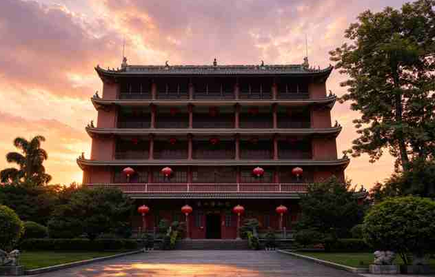
The Five-Story Tower is Zhenhai Tower. It sits at the highest point of Yuexiu Mountain. It is the northern starting point of Guangzhou's modern axis, and it is the highest point of the old city.
Why was it built here?
In the early Ming dynasty, the Marquis of Yongjia, Zhu Liangzu, expanded the city wall up Yuexiu Mountain. Legend says he had a dream: a red dragon flew out of Yuexiu Mountain, and a green dragon rose from the Pearl River. The two fought. Zhu Yuanzhang's advisor Liu Bowen interpreted the dream: this was a sea demon. Build a tower to suppress it.
So Zhu Liangzu built the tower at the highest point of Yuexiu Mountain — on the site of the old Yuewang Terrace of the Southern Yue kingdom. It was first called "Wanghai Tower" — the Tower for Watching the Sea. Later it was renamed "Zhenhai Tower" — the Tower that Guards the Sea.
The Pearl River used to be more than a kilometer wide — five or six times wider than it is today. Standing on Zhenhai Tower, you really could see the sea.
In 1929, it became the Guangzhou Museum — the first museum in Lingnan.
Sun Yat-sen Memorial Monument: the bell on the mountain
Walking south from Zhenhai Tower, down Yuexiu Mountain, you reach the Sun Yat-sen Memorial Monument.
Built in 1929, it was designed by the same architect as the Sun Yat-sen Memorial Hall: Lü Yanzhi. The monument is made of granite, shaped like a bell, meaning "to awaken the people."
Why here? Because this is the highest point of Yuexiu Mountain, and the highest point of the old city. Sun Yat-sen often came here during the revolutionary years.
Sun Yat-sen Memorial Hall: the heart of the modern axis
Continue south, and you reach the Sun Yat-sen Memorial Hall.
Built in 1931, it is the largest Sun Yat-sen memorial hall in the world. It is also a model of combining Chinese architectural style with Western engineering.
The story is tied to Guangzhou's revolutionary history. After Sun Yat-sen died in Beijing in 1925, the people of Guangzhou decided to build a memorial hall on the site where he had once been sworn in as Extraordinary President. The architect, Lü Yanzhi, used a "Chinese roof + Western steel frame" design, so that a hall that could seat thousands would still look like a palace.
The original blueprints are now a treasure of the Guangzhou Municipal Archives. Next to the hall is a 350-year-old kapok tree, known as the "King of Kapok."
The Guangzhou Municipal Government Building: the stage of modern history
Continue south, and you reach the Guangzhou Municipal Government Building.
This place has been the center of power in Guangzhou since the Qing dynasty.
In the Qing dynasty, this was the Office of the Governor-General of Liangguang — the highest official overseeing Guangdong and Guangxi. Lin Zexu planned the opium ban here. Zhang Zhidong ran his reforms here.
The 1911 Revolution was won here. On October 10, 1911, the Wuchang Uprising broke out. On October 29, revolutionaries in Guangzhou rose up and took the Governor-General's Office. Qing rule in Guangzhou ended here.
In the Republican period, this became the Guangzhou Municipal Government. In 1921, Guangzhou was formally established as a city. The building you see today was designed by Lin Keming and completed in 1931. It faces south, with yellow glazed tiles, green ridges, red pillars, and yellow walls — echoing the style of the Sun Yat-sen Memorial Hall.
In 1949, when Guangzhou was liberated, the PLA's entry ceremony was held in front of this building. Ye Jianying, the first mayor after liberation, reviewed the troops here. Since then, it has been the office of the Guangzhou Municipal People's Government.
So this building is not just an office.
It is the stage of modern Guangzhou:
- Qing dynasty: the Governor-General's Office.
- 1911: the revolution that ended Qing rule.
- Republican era: the city government.
- 1949: the PLA entry ceremony.
- Today: the People's Government.
One building, two hundred years of power.
People's Park: the first public park in Guangzhou
Across from the government building is People's Park.
Its former name was First Park, built in 1918. It was the first modern public park in Guangzhou.
Why does this matter? Because before this, Guangzhou people had no concept of a "park." There were only private gardens and temples. After First Park opened, ordinary people had a public space — a place to walk, to drink tea, to listen to opera.
It was also the first public facility built on the modern axis.
The trees in the park are older than the park itself.
In the Qing dynasty, this was the back garden of the Office of the Guangdong Governor. The governor was the highest official in Guangdong, and his office stood on this exact site.
In 1911, after the revolution, the governor's office was abolished, and the land was left empty. In 1918, it was turned into First Park.
But the trees were not moved.
The banyans, kapoks, and mango trees were planted in the Qing dynasty, or even earlier. Some of the banyans are now over 300 years old.
So when you walk into People's Park, you are not looking at the park's trees. You are looking at the trees of a Qing dynasty governor's garden.
They are older than the park. Older than the Republic. Older than the Qing.
Guangzhou Uprising Road: the red memory on the axis
South of People's Park is Guangzhou Uprising Road.
The road is named after an uprising. In December 1927, Communists Zhang Tailei, Ye Ting, and Ye Jianying led the Guangzhou Uprising here, establishing the first urban soviet government in China.
The uprising lasted only three days before it failed. But in Chinese revolutionary history, it stands alongside the Nanchang Uprising and the Autumn Harvest Uprising as one of the three great uprisings.
The road name commemorates it.
Haizhu Square: the starting point of the Canton Fair
Continue south, and you reach Haizhu Square.
It is tied to the history of China's foreign trade.
In 1957, the first Canton Fair was held nearby, in the Sino-Soviet Friendship Building. Later it moved to the Haizhu Square area, where it was held for 16 years and 32 sessions.
So Haizhu Square is not just a square. It is the starting point of China's export trade.
In the center of the square stands the Guangzhou Liberation Monument.
On October 14, 1949, the PLA entered Guangzhou. Guangzhou was liberated.
In 1959, to mark the tenth anniversary of liberation, the city built a monument in the center of Haizhu Square. The body is granite, topped with a five-pointed star.
It stands with Haizhu Bridge as a pair. Haizhu Bridge, built in 1933, was the first bridge across the Pearl River in Guangzhou. In 1949, the PLA entered the city across this bridge. The monument and the bridge — one north, one south, across the square — tell the same story: Guangzhou was liberated.
Haizhu Bridge: the first bridge across the Pearl River
Finally, Haizhu Bridge.
Built in 1933, it was the first bridge across the Pearl River in Guangzhou. It is the southern end of the modern axis — it pulled the axis from Yuexiu Mountain all the way across the river.
It was originally designed as a drawbridge.
In the 1930s, river traffic was busy. Large ships needed to pass. If the bridge were fixed, it would have to be very high, with long ramps on both sides — not suitable for the river conditions at the time.
So the designers made the middle section openable. When a large ship needed to pass, the middle section would split and lift upward. After the ship passed, it would close again. The whole process took about five minutes.
Why can it no longer open?
Because of war.
In 1938, Japanese bombers attacked Guangzhou, damaging the opening mechanism. More critically, Japanese forces later stole the entire opening mechanism. Without it, the bridge lost its ability to open. It was repaired later, but the opening section could never be restored.
From that point on, Haizhu Bridge could only let small boats pass. Large ships had to dock at Huangpu.
In 1949, retreating Nationalist forces blew up the bridge. The bridge you see today was rebuilt in 1950 — and from the start, it was not designed to open.
Beijing Road: the other axis, the ancient one
The axis described above is the modern axis. Guangzhou also has an ancient axis, centered on Beijing Road.
It is older than the modern axis.
Beijing Road has been the center of Guangzhou since the Qin dynasty, more than 2,200 years ago — and it has never moved. Beneath the road, archaeologists found 11 layers of pavement, from the Tang, Southern Han, Song, Yuan, Ming, Qing, Republican, and modern periods.
Why does this matter? Because since the Qin dynasty established its commandery system, this has been the administrative and commercial center of Guangzhou. Every highest official of Guangzhou, in every dynasty, had their office nearby.
The middle section of Beijing Road was called "Shuangmen Di" — Double Gate Bottom. In the Tang and Song dynasties, there was a "Gongbei Tower" with two parallel gates. In the Yuan dynasty, a bronze water clock was placed on the tower — the city's official timekeeper.
At the southern end of Beijing Road is Tianzi Pier. The ancient axis ends here. The Pearl River begins here.
Two axes, two thousand years
The ancient axis: Nanyue Palace → Beijing Road → Tianzi Pier. More than 2,200 years, never moved.
The modern axis: Zhenhai Tower → Sun Yat-sen Monument → Sun Yat-sen Memorial Hall → Municipal Government → People's Park → Uprising Road → Haizhu Square → Haizhu Bridge. From the Ming dynasty to the Republic, one line.
Beijing's central axis is a straight line. Guangzhou's axes are not straight. They follow the mountain. They follow the river.
But what they connect is older than Beijing's.
This is Guangzhou.
Not sure which element is missing from your chart? Take the free Five Elements test at wuxingvibe.com/reading — it takes 60 seconds, and it tells you which stones are for you.
Find your element
Take the free Five Elements test